A PhD student at the University of Leeds has developed a fast, accurate and inexpensive method of creating detailed vegetation community maps over very large areas.
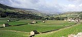
Working in partnership with the Yorkshire Dales National Park Authority, Ute Bradter from Leeds' Faculty of Biological Sciences, has collated existing data (such as soil type, altitude, slope and aspect) and using a sophisticated statistical model, predicted the distribution of plant communities at a high resolution in the Yorkshire Dales, over 1600 km2.
Her results, published today (01 June) in the British Ecological Society's Journal of Applied Ecology showed an accuracy of up to 92 per cent, comparable with the traditional mapping method of on-site surveys conducted by trained ecologists. Detailed and high resolution vegetation maps noting species distribution are a crucial resource for land management, conservation planning, environmental monitoring and research. But manual mapping is a slow and expensive process, and faster, reliable methods are much needed.
Automatic mapping using aerial or satellite photography has been attempted, but until now, achieving reliable degrees of accuracy has proven difficult. "What Ute has achieved is remarkable," says her supervisor and co-author Professor Tim Benton. "To put it into perspective, it would take sixteen years of day-in, day-out sampling for one experienced ecologist to replicate this particular mapping exercise by hand."
Vegetation in an area is classified into different communities depending on the range of species and their abundance. Communities can be described in detail, for example there are 22 vegetation communities on British heaths alone. The Leeds research combined information and datasets from a range of readily available sources, such as soil maps, standard ordnance survey maps and aerial photography.
The predictions were categorised into 24 National Vegetation Classification groups (plus an extra catch-all category of "wood") to a 5m resolution. "The statistical model is highly accurate because of the diverse range of information we used," says Bradter. "The high resolution aerial photography gave us added colour and texture - for example to differentiate wooded areas from other areas - but we incorporated additional physical information into the model, such as topographical measurements of slopes and elevation, and information from different spatial scales."
"Our approach shows that even for relatively complex vegetation classifications it is possible to produce accurate maps over hundreds of square kilometres. We're particularly pleased given that some vegetation communities are difficult to distinguish even using trained field workers," she adds.
If further research confirms that the method performs as well in other environments, such as lowland areas, Bradter is confident that it could be used to accurately assess the conservation value of land in other regions and countries where similar datasets are available. Co-author and Senior Wildlife Conservation Officer at YDNPA, Dr Tim Thom, says: "This method also has the potential to be used for a wide range of other environmental purposes, such as identifying rare habitat, or where drainage ditches are grown over and so pose a flood risk, or where erosion-risk is high in areas of bare peat.
What's most exciting is that if we can map the plants accurately, we can also make a better guess what animals live there too, so we could also remotely monitor biodiversity across the farmed habitat or predict the potential value of setting aside pockets of land for conservation as part of agri-environmental schemes." The research was funded and co-supervised by the Yorkshire Dales National Park Authority.
Ute Bradter is available for interview.
For further information:
Please contact the University of Leeds Press Office on +44 (0)113 343 4031 or email pressoffice@leeds.ac.uk
Notes for editors:
Prediction of National Vegetation Classification (NVC) communities in the British uplands using environmental data at multiple spatial scales, aerial images and the classifier random forest Bradter, Ute; Thom, Tim; Altringham, John; Kunin, William; Benton, Tim
DOI: 10.1111/j.1365-2664.2011.02010.x
A copy of the paper is available on request.
The Faculty of Biological Sciences at the University of Leeds is one of the largest in the UK, with over 150 academic staff and over 400 postdoctoral fellows and postgraduate students. The Faculty is ranked 4th in the UK (Nature Journal, 457 (2009) doi :10.1038/457013a) based on results of the 2008 Research Assessment Exercise (RAE). The RAE feedback noted that "virtually all outputs were assessed as being recognized internationally, with many (60%) being internationally excellent or world-leading" in quality. The Faculty's research grant portfolio totals some £60M and funders include charities, research councils, the European Union and industry.
The University of Leeds is one of the largest higher education institutions in the UK with more than 30,000 students from 130 countries. With a turnover approaching £450m, Leeds is one of the top ten research universities in the UK, and a member of the Russell Group of research-intensive universities. It was placed 80th in the 2007 Times Higher Education world universities league table. The University's vision is to secure a place among the world's top 50 by 2015.
Yorkshire Dales National Park Authority (YDNPA) - The Yorkshire Dales National Park Authority is an independent, public body within the local government structure, created by the Environment Act (1995). We provide some of the services that are similar to those provided elsewhere by district and county councils - for example we are the local planning authority and have a responsibility for the maintenance of rights of way in the Yorkshire Dales National Park. However, most of the things we do are unique to national park authorities.
The Yorkshire Dales National Park Authority has two main purposes:
-
to conserve and enhance the natural beauty, wildlife and cultural heritage of the area; and
- to promote opportunities for the understanding and enjoyment of the special qualities of the National Park by the public.
In carrying out these aims, we also have a duty to seek to foster the economic and social well-being of local communities.
Journal of Applied Ecology is published by Wiley-Blackwell for the British Ecological Society.